Along with automated BSEF analysis and the
creation of the attribute sections of the investigated subsurface environment
and the wave field reflected from it based on this analysis, the
GEORADAR-EXPERT implements a complete set of data processing methods that
should be present in every software for processing GPR information. These are
various types of signal transform, control of the geometry and visualization of
the GPR profile, working with manually created user layer boundaries, combining
two-dimensional GPR data into a three-dimensional assembly, and much more. In
other words, the GEORADAR-EXPERT software system has everything that a GPR
specialist is used to working with.
Along
with the widely used methods of processing GPR data, algorithms and methods
have been specially developed for the GEORADAR-EXPERT to effectively increase
the resolution of GPR profile signals and suppress difficult interference.
The B-Detector (Boundaries Detector)
method, specially developed for the GEORADAR EXPERT, is designed to suppress
interference and increase the vertical resolution of the GPR profile, which
makes it easier to distinguish nearby, vertically, reflections from the
boundaries of subsurface layers. Using B-Detector, the user increases the
frequency and spectrum width of the GPR profile signals, thereby reducing the
duration of these signals and increasing the degree of detail of the GPR
profile.
As a result of processing by the B-Detector
method, the GPR profile obtained using a low-frequency antenna looks as if the
frequency of the GPR antenna for recording this GPR profile was tuned to a
frequency several times higher than the actual frequency of the antenna. Compared
to the original GPR profile, the vertical resolution of the GPR profile after
processing by the B-Detector method is several times higher. If necessary, the
B-Detector method can lower the central frequency of the GPR profile signals.
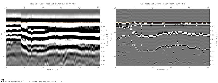
Further, as an example of the application of the B-Detector
method, the GPR profile recorded during the survey of the road pavement with a
1200 MHz GPR is considered, see the figure below on the left. Starting
from the 4 m distance along the profile, the asphalt concrete pavement of the
highway consists of two layers. According to a priori information, the upper
layer of asphalt concrete has an average thickness of 0.04 m, the lower
boundary of the second layer of asphalt concrete lies in the depth range from
0.12 to 0.15 m from the surface of the pavement. Below is a layer of crushed
stone base, the thickness of which, on average, is 0.15 m. Not all reflections
from the boundaries of these layers are noticeable on the raw GPR profile. For
example, it is difficult to detect a reflection from the contact boundary of
asphalt concrete layers at a depth of 0.04 m. From this it can be concluded
that the 1200 MHz antenna does not provide sufficient resolution of the GPR
profile for a detailed study of the road layers.
In such a situation, it would seem logical to
use a higher frequency antenna that emits radio pulses of shorter duration,
which would improve the resolution of the signals. But with increasing
frequency, the attenuation of the radio pulse increases, which means that
choosing a higher frequency GPR antenna will lead to a decrease in the depth of
the GPR survey. For this reason, at the hardware level, it is impossible to
achieve an improvement in the vertical resolution of the GPR profile without
reducing the depth of the GPR survey. At the software level, to some extent,
this problem can be solved using the B-Detector method.
The figure above on the right shows the
result of processing the considered GPR profile by the B-Detector method. As a
result of using this method, the resolution of the GPR profile has
significantly increased. Reflections from the boundaries of road layers have
become compact, do not overlap each other, and are well distinguished. Phase
distortions caused by the mutual influence of reflections from nearby
boundaries have disappeared. Aligned reflection phases make the GPR profile
well adapted to the process of automated
boundaries picking, which is implemented in the GEORADAR-EXPERT software
system. The availability of the automated
boundaries picking option is important for processing large amounts of
data, for example, obtained during road or railway GPR surveys.
Next, as another example, the result of GPR
profiling of a highway with a 400 MHz GPR is presented. The upper figure shows
the raw GPR profile, below is the result of its processing by the B-Detector
method.
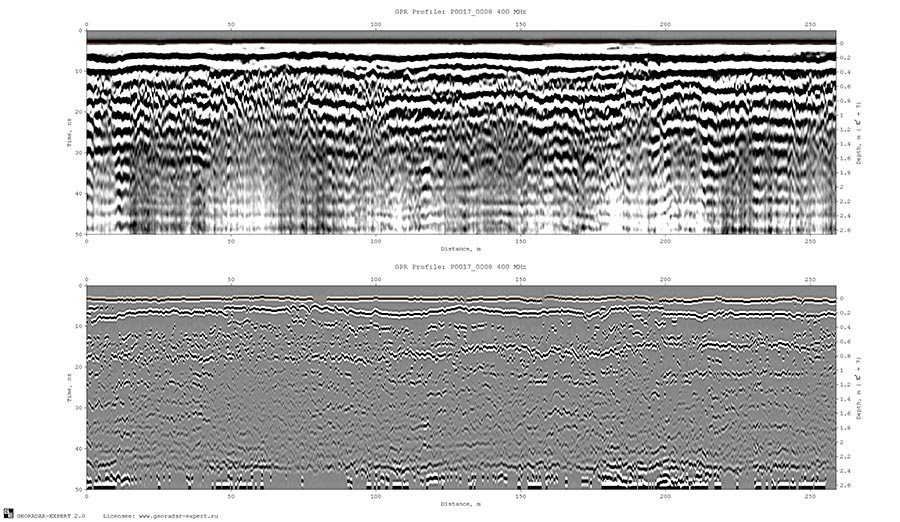
As a result of the application of the B-Detector method, the lower boundary of the road pavement is clearly visible on the processed GPR profile, the depth of which varies around the 0.2 m tick. This boundary is difficult to fully detect on an unprocessed GPR profile. The figure below shows on the left the amplitude-frequency spectrum of the signals of the original GPR profile, on the right is the spectrum of the GPR profile after applying the B-Detector method.
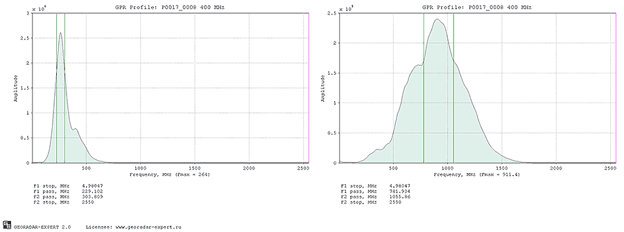
As a result of using the B-Detector method,
the central frequency of GPR profile signals increased approximately 3.5 times
– from 264 MHz to 911.4 MHz. The width of the signal spectrum has increased 3.7
times – from 74.7 MHz to 277 MHz. An increase in the width of the signal
spectrum indicates a decrease in its duration, which leads to an improvement in
the vertical resolution of signals on the GPR profile. Thus, as a result of
using the B-Detector method, the GPR profile looks as if it was obtained not by
a 400 MHz GPR, but by a hypothetical higher-frequency GPR with a central
frequency of 400 *3.5= 1400 MHz, providing a greater penetration depth of the probing
pulse, which is not typical for a high-frequency GPR.
Often, in a road survey, it is required to
obtain two GPR profiles for the same location. One GPR profile is recorded
using a high-frequency antenna that provides penetration of the probing pulse
to a depth of about 1 meter. This entry is used to study the pavement layers.
The second GPR profile is recorded using a lower frequency antenna that
provides a depth of 3 - 8 meters. Such an antenna is suitable for the study of
soils under the road.
If a single-channel GPR is used, which does
not provide simultaneous operation of two antennas tuned to different
frequencies, then to record two GPR profiles in the same place, it is necessary
to pass the same route with different GPR antennas twice.
In such a case, using the B-Detector
method, it is possible to achieve a compromise between the time spent on
recording and processing GPR data and the quality of the GPR study result.
Using the B-Detector method and one midrange antenna, for example, a 400 MHz
antenna, as in the example under consideration, will reduce the volume of field
and cameral work by half. Taking into account the significant mileage of GPR
profiling during road works, this is a significant economy.
Another argument in favor of using the
B-Detector method. A small geophysical company may not have a full set of GPR
antennas that cover the entire range of operating frequencies of
georadolocation to solve a wide range of tasks. The acquisition of a large
amount of geophysical equipment requires significant financial costs, and this
is sensitive for a small company. The use of the B-Detector method will allow
you to save on high-frequency antennas, allowing you to have one
medium-frequency and one low-frequency antenna available for some time, for
example, 500 and 100 MHz.
Along with the B-Detector method, an
increase in the vertical resolution of the GPR profile in the GEORADAR-EXPERT
software system can be performed using wavelet decomposition. This transform
resembles a windowed Fourier transform, only in the Fourier transform the
signal is decomposed into components in the form of sines and cosines, and in
the wavelet decomposition the decomposition is performed using special
functions - wavelets, the graph of which resembles a GPR probing pulse in
shape. After the wavelet decomposition, the signals is restored by
high-frequency decomposition levels. The central frequency of the restored
signals and the width of its spectrum is greater than that of the original
signals, which means that the restored signals is shorter than the original
one. And if the signals is shorter, then the vertical resolution of such
signals is better.
Below
is a comparison of the results of using the methods of B-Detector (upper image)
and wavelet decomposition of signals.
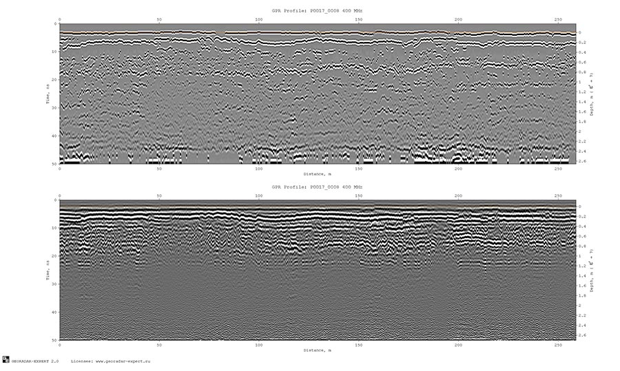
Each of the presented methods of increasing the
resolution of GPR data has its advantages. The user, depending on the features
of the GPR profile wave field and the tasks of GPR research, can choose which
of these methods to use in each specific case.
Interference and Air Reflections Suppression
One of the problems faced by a specialist
in processing GPR data is the suppression of reflections from objects located
on the surface. These so-called air reflections often have a high level of
amplitudes, which allows them to mask reflections from subsurface objects well.
Shielding GPR antennas does not allow you to completely get rid of these air
reflections. To the greatest extent, air reflections are manifested on GPR
profiles obtained using dipole low-frequency antennas, where shielding is not
provided. Also, diffracted reflections from contrasting local objects lying at
a shallow depth can act as interference.
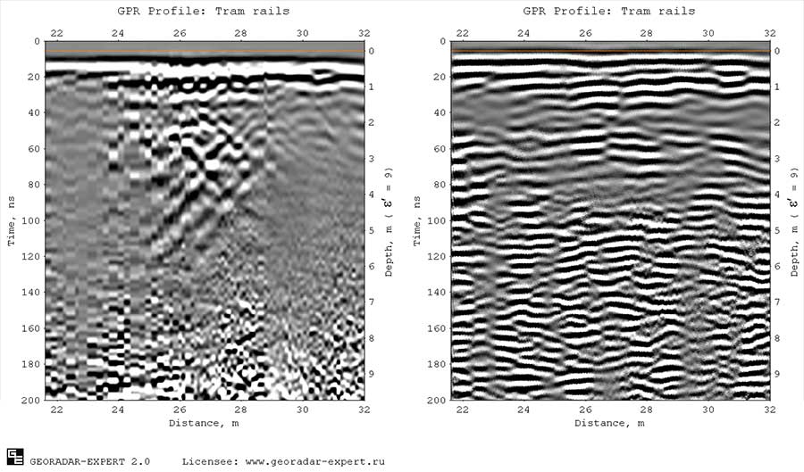
The
spatial filter implemented in the GEORADAR-EXPERT software system allows you to
solve the above problem. As an example of suppressing intense masking
interference using a spatial filter, a profile obtained by a 150 MHz GPR that
crosses tram tracks is taken. The figure below on the left shows the raw GPR
profile, in which intense reflections from metal rails and ground
infrastructure objects are superimposed on weaker reflections from the
boundaries of layers in the ground. The result of spatial filtering is shown on
the right. Diffracted reflections-interference is suppressed and does not mask
reflections from the boundaries of the layers.
Along with the spatial filter, the
GEORADAR-EXPERT software system implements interference removal by decomposing
GPR profile signals into components. If the GPR profile signal matrix is
decomposed into components, and then restored, having previously discarded
those decomposition levels that contain information about interference, then
there will be no interference on the restored GPR profile. Each level of decomposition contains its own
characteristic features of signals. The lower levels contain spatially extended
horizontally oriented components of the GPR profile. The higher the
decomposition level, the more compact the decomposition components become.
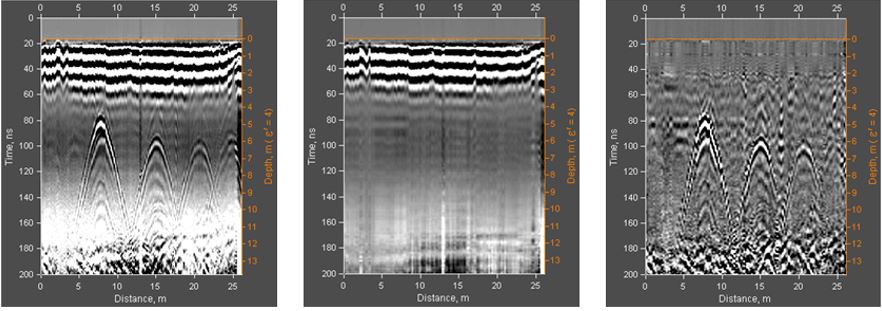
The
following is an example of the application of decomposition into components. On
the left is an example of a GPR profile that contains two types of waves. These
are extended subhorizontal reflections and diffracted reflections, which look
like hyperbolas on the GPR profile. The center shows the result of the
restoration of this GPR profile by the lower levels of decomposition. It is
noticeable that characteristic reflections in the form of hyperbolas have
disappeared on the profile. On the right is the result of recovery by the
higher levels of decomposition. In this case, information about subhorizontal
extended reflections is discarded, and diffracted reflections are not affected.
The GEORADAR-EXPERT software system has
more than two dozen options designed for processing GPR profile signals. With
the help of these options, almost the entire range of tasks that a user may
have in the process of processing GPR data is solved. The user can save the
sequence of applying data processing options to a file and apply this sequence
in the future.
Automation
of user actions for processing the same type of GPR data frees him from being
at the computer. In batch processing mode, the user has to set processing
parameters and select a group of GPR profile files, after which the
downloading, processing and saving of the processing result is done
automatically, without the user's involvement.
This review describes only some of the options for processing GPR data specially developed for the GEORADAR EXPERT. For a full description of the capabilities of the GEORADAR-EXPERT software system, see the user manual, which can be downloaded using this button: